- Resources
- Scaling air quality solutions
Resources
Scaling air quality solutions
Published: November 16, 2019 by EDF Staff
Imagine a world in which companies support telecommuting when the air is dirty, where parents can effectively consider air quality when deciding on where to live or send their kids to school or where cities offer discounted public transportation to the most affected communities.
Innovative technologies hold tremendous potential for improving our understanding of air pollution – helping find out more about what’s in the air we’re breathing.
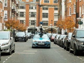
That’s why EDF and partners like Google Earth Outreach are piloting a range of studies from Oakland to London featuring new, lower-cost sensors, to help us map air pollution at the hyperlocal level. This new generation of sensors can be mounted on cars, trucks and even bicycles , or in denser stationary networks than previous monitors.
In Oakland, California, EDF and our partners developed air pollution maps using data from a combination of stationary and mobile monitors. By combining these results with electronic health records, we could map associated health risks by neighborhood. Community leaders used them to advocate for mitigation efforts under a new air quality law seeking to cut pollution in California’s most affected communities.
In addition to measuring air pollution via Google Street View cars in neighborhoods around Houston, Texas, EDF leaders worked with key city staff to test how sensor systems on municipal vehicles could alert the city to air pollution threats and determine how many sensor-equipped vehicles it would take to map air pollution across the entire city. We also worked with city officials in the wake of Hurricane Harvey to measure emission events that occurred following damage to the region’s petrochemical facilities, which provided a community with information about high concentrations of benzene, a known carcinogen.
Building upon our work in the U.S., EDF along with the Mayor of London, Google, C40 Cities and others recently launched Breathe London, which combines sophisticated data analytics with state-of-the-art technology , such as mobile monitoring on Google Street View cars and over 100 stationary monitors , to collect air pollution data points at thousands of locations. This is one of the world’s most comprehensive air quality monitoring networks in one of its busiest and most complex cities. These data create a baseline to help London design, tailor and understand the impact of future clean air actions.